
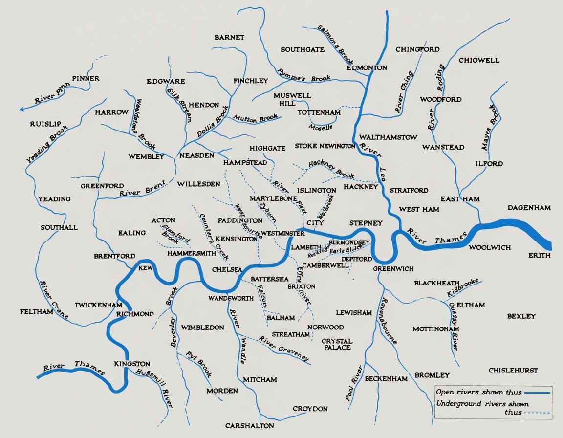
45 Good Long Walks on Waterways in or Near London
💥Trespasses extensively into the Home Counties 💥Excludes the Thames 💥But 𝘪𝘯𝘤𝘭𝘶𝘥𝘦𝘴 unhelpful and irrelevant field notes, and poems.

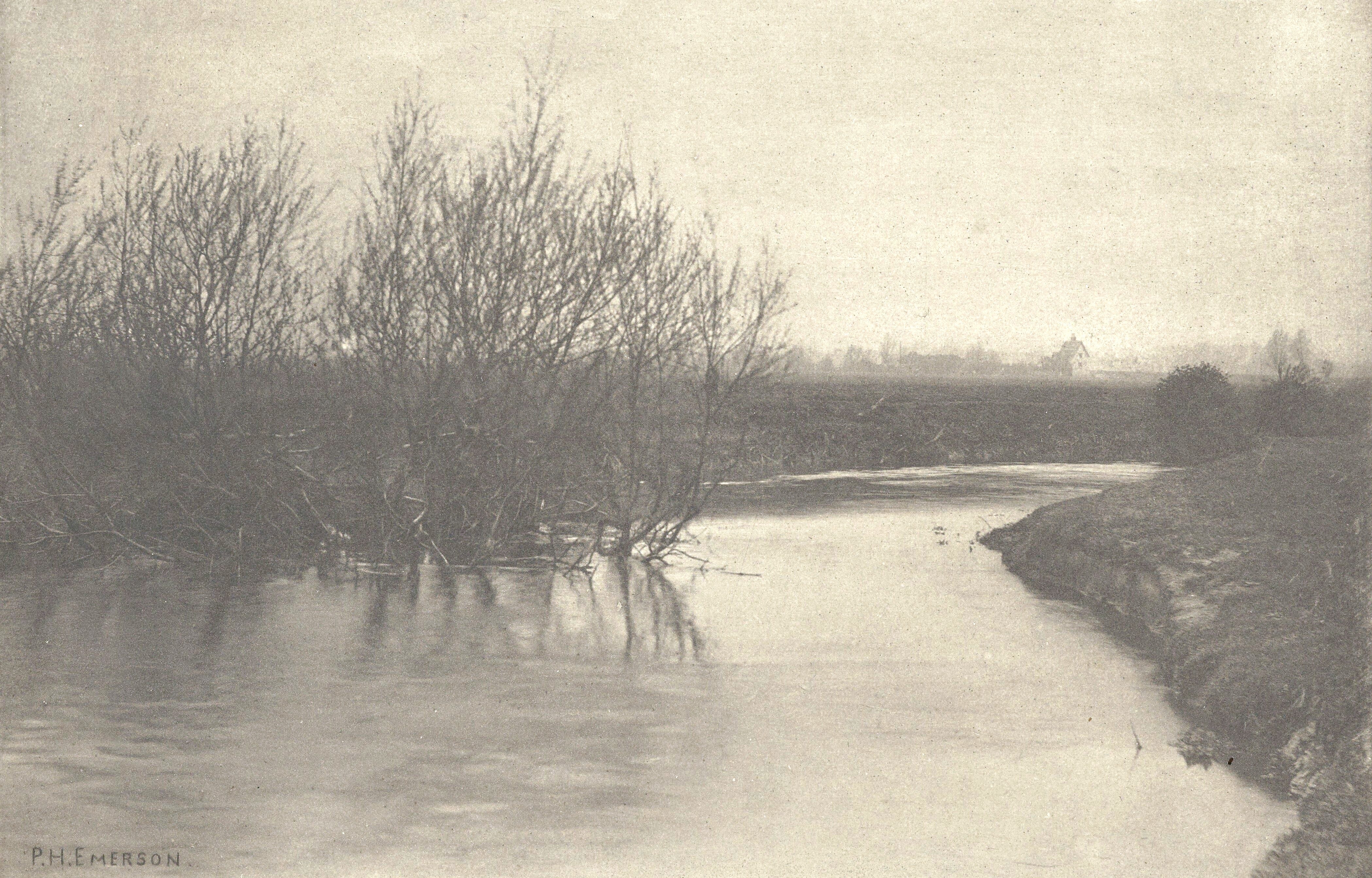
London was spread out before me, a vast campagne.
    —W. N. P. Barbellion
…the huge peaceful wilderness of outer London…
    —George Orwell
The following are not detailed route descriptions, but suggested start and end points to walk between, preferably with the Ordnance Survey app. The OS screenshots show the start of each water walk and, if possible, the nearest railway or tube station.
Basingstoke Canal
Western half
Hampshire and Surrey.
~20 miles
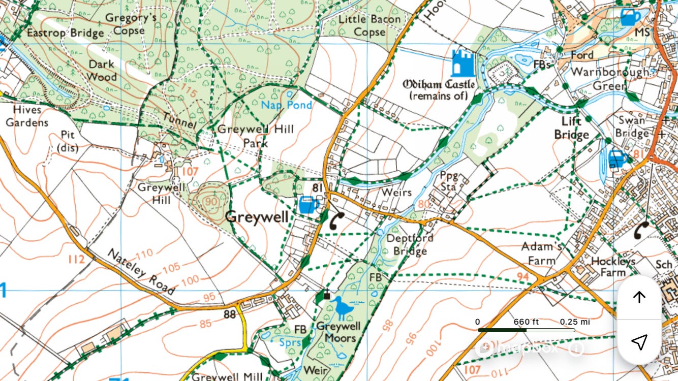
Train to ◉Hook
Walk south to join the canal at Greywell
Walk east on the towpath to ◉Ash Vale
Field notes: It took longer than expected to get from Hook station to the towpath at the eastern end of Greywell tunnel. Locked gates around Carleton’s Gorse and cattle in Gaine’s Wood. Long walk – it was dark by the time I got to Ash Vale. Saw a kingfisher near Aldershot.


Eastern half
Surrey.
~15 miles
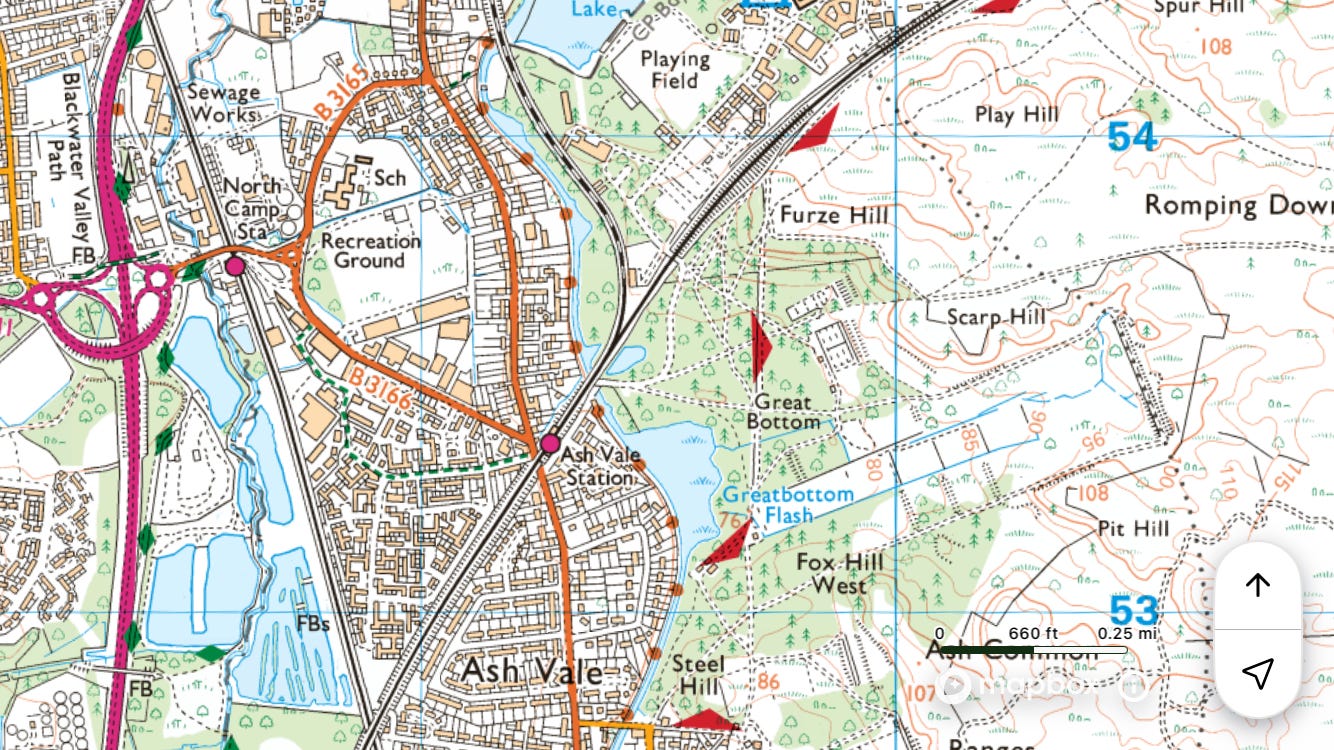
Field notes: Narrowly avoided going off in the wrong direction when the train split at Woking. Passed an angler who had just caught an enormous mirror carp and was posing with it for photos. The canal is pretty much drained around Pirbright Camp and Deepcut Barracks.


Beverley Brook
~8 miles
Train to ◉New Malden
Walk north on the Beverley Brook Walk to the Thames / ◉Putney or ◉Barnes
Field notes: At Palewell Common there’s a fence between Beverley Brook Walk and Beverley Brook, putting the latter literally beyond the pale, ‘An area enclosed by a fence’ (OED).


River Brent
Northern half
~8 miles
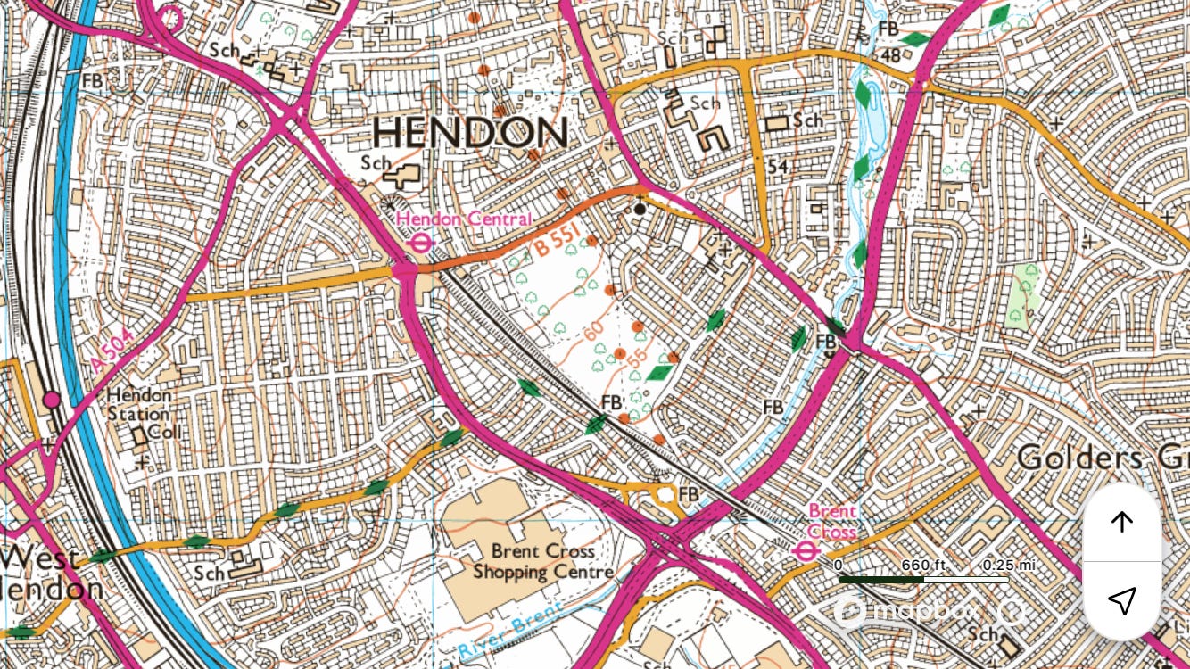
Tube to ◉Hendon Central
Walk south to ◉Hanger Lane
Field notes: The sunny photos make it look nice, but would not recommend. Litter-plus and weed smoke all the way. Loads of Japanese knotweed in Brent River Park, Tokyngton. The London Encyclopædia: ‘In 1890 it was said that above the Welsh Harp sewage flowed down the Brent and that between Hanwell and Ealing even the water rats had fallen victims to the foulness of the Stream.’1


Southern half (incorporating part of the Grand Union Canal)
~7 miles
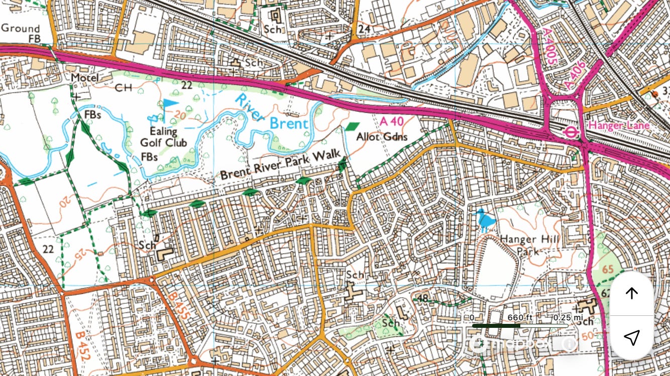
Tube to ◉Hanger Lane
Walk south on the Brent River Park Walk to the Thames / ◉Brentford
Field notes: It’s not as rewarding as some other walks – an unmaintained path to the point of non-existence. I blundered around in a jungle just south of the A40, retreated, went along the road for a bit, and through Brent Valley Golf Club. It doesn’t become a proper riverside walk until Greenford, and then it’s not that far to Hanwell and the confluence with the Grand Union Canal.


River Ching
Partly in Essex.
~10 miles
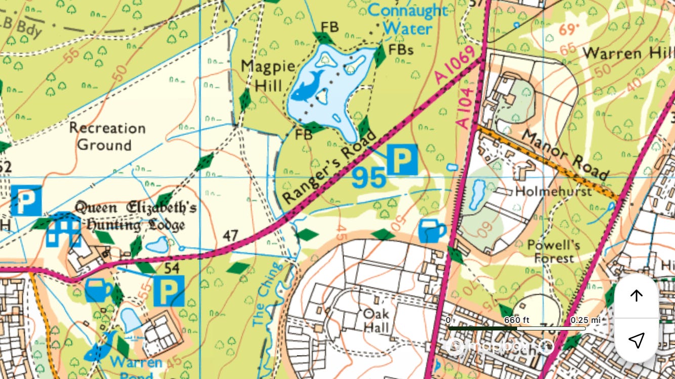
Tube to ◉Epping
Walk south through Epping Forest to the source of the Ching at Connaught Water
Walk south to the Lee / ◉Highams Park
Field notes: This is a good opportunity to go to the end of the Central line, to Epping, and then walk back towards London through the whole of Epping Forest, picking up the Ching at its source near Connaught Water.


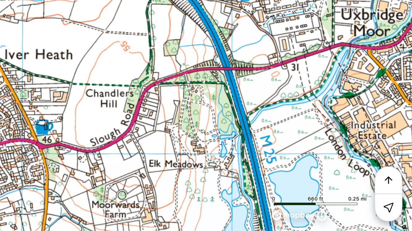
River Colne
Northern section
See Grand Union Canal.
Southern section (incorporating part of Colne Brook)
Technically not Greater London – the Colne is the Middlesex–Buckinghamshire border.
~13 miles

Elizabeth line to ◉West Drayton
Walk south on the Colne Valley Trail/Way to the Thames / ◉Staines
Field notes: Fantastic walk, though much of it is not actually by the river – sometimes you’re by Colne Brook, a distributary of the Colne. The one bit when I felt like I was somewhere I wasn’t meant to be was coming into Horton, where the path goes through the yard of a skip hire business and past Berkyn Manor Farm, where Milton once lived (in an earlier house). In London Orbital, his wonderful book about M25 country, Iain Sinclair calls Staines Moor ‘the most inspiring section we have so far encountered on our M25 orbit.’2 In orbital terms I walked between junctions 15 and 13. On the train back to Richmond I went into the empty first-class carriage and it was worse than the rest of the train – the same, but with a shitty nylon curtain that flapped annoyingly at me.


Colne Brook
Buckinghamshire.
~13 miles
Tube to ◉Uxbridge
Walk west to join the river where is splits from the Colne at Uxbridge Moor
Walk south, partly on the Colne Valley Trail/Way and Colnbrook Walk, to the Thames / ◉Staines
Field notes: ‘Where would you like to be when the world ends?’


River Crane
~10 miles
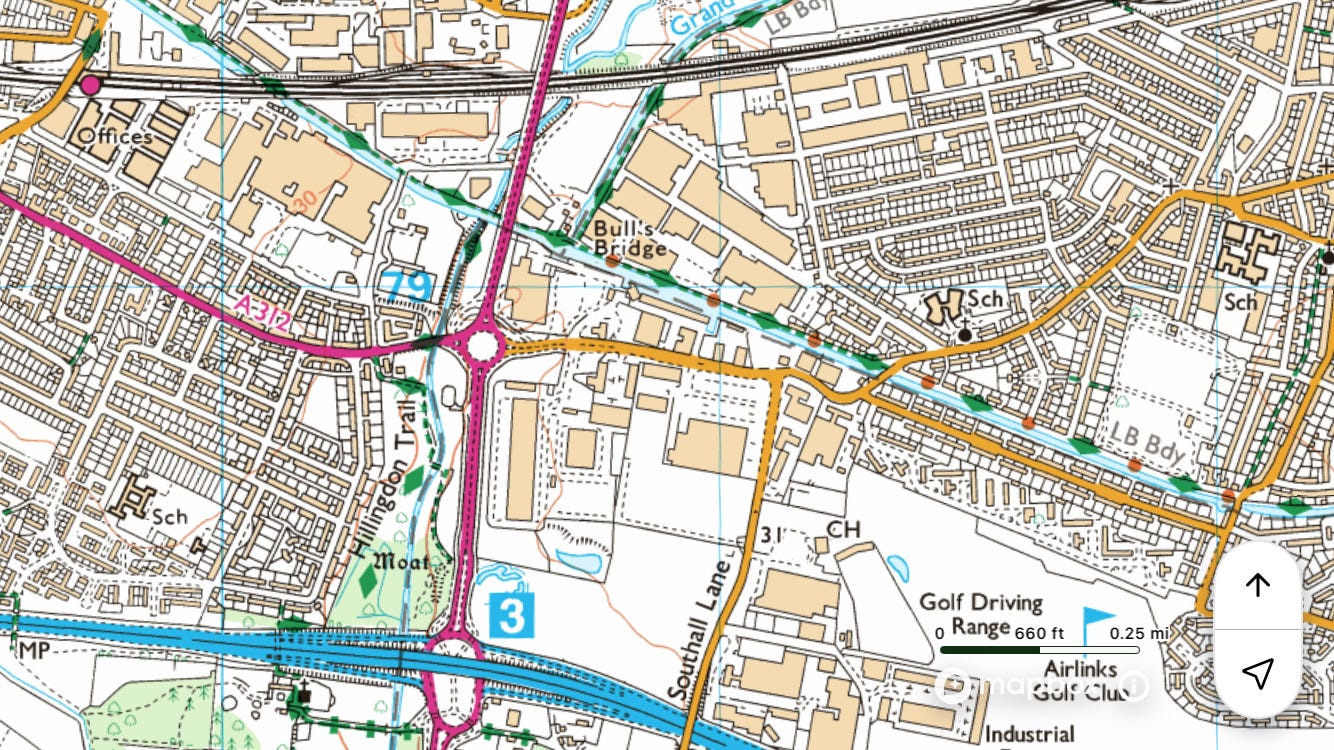
Elizabeth line to ◉Hayes and Harlington
Walk along the Grand Union Canal and join the Crane just west of the A312
Walk east on the Crane Valley Trail to the Thames / ◉Isleworth
Field notes: The river forms part of the border between the Boroughs of Hounslow to the east and Hillingdon to the west, Heathrow Airport being in the latter even though it is situated on what used to be Hounslow Heath, hence its name. Highlights of the walk include Cranford Countryside Park, Cranebank, and Crane Park. See Yeading Brook for the upper course of the river.


River Cray
~13 miles
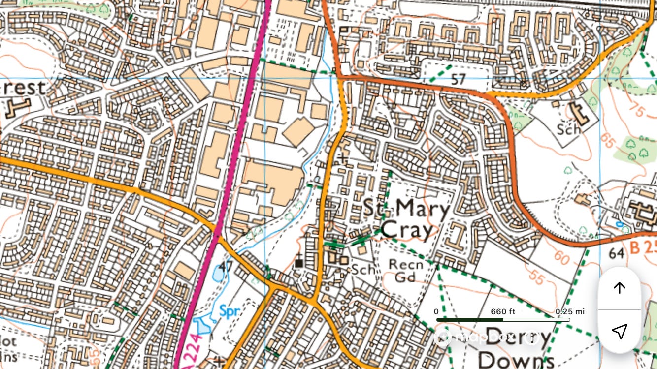
Train to ◉Orpington
Walk north on the Cray Riverway to the Darent / ◉Slade Green
Field notes: The Cray Riverway is signed from Foots Cray. Youths on motorbikes at Dartford Creek.


River Darent
Kent.
~19 miles
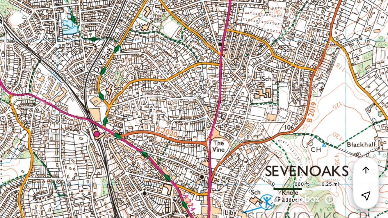
Train to ◉Sevenoaks
Walk north on the Darent Valley Path to the Thames / ◉Dartford
Field notes: It’s very well signed. The only bit that posed a problem was near junction 2 of the M25, where the OS has the route cross a footbridge obstructed by a locked gate, and does not mark the actual footbridge to use, which is two hundred yards to the north. So I ended up climbing into and out of a desolate bit of waste ground next to Darenth Road.


Dollis Brook
Incorporating part of Mutton Brook
Starts in Hertfordshire.
~13 miles
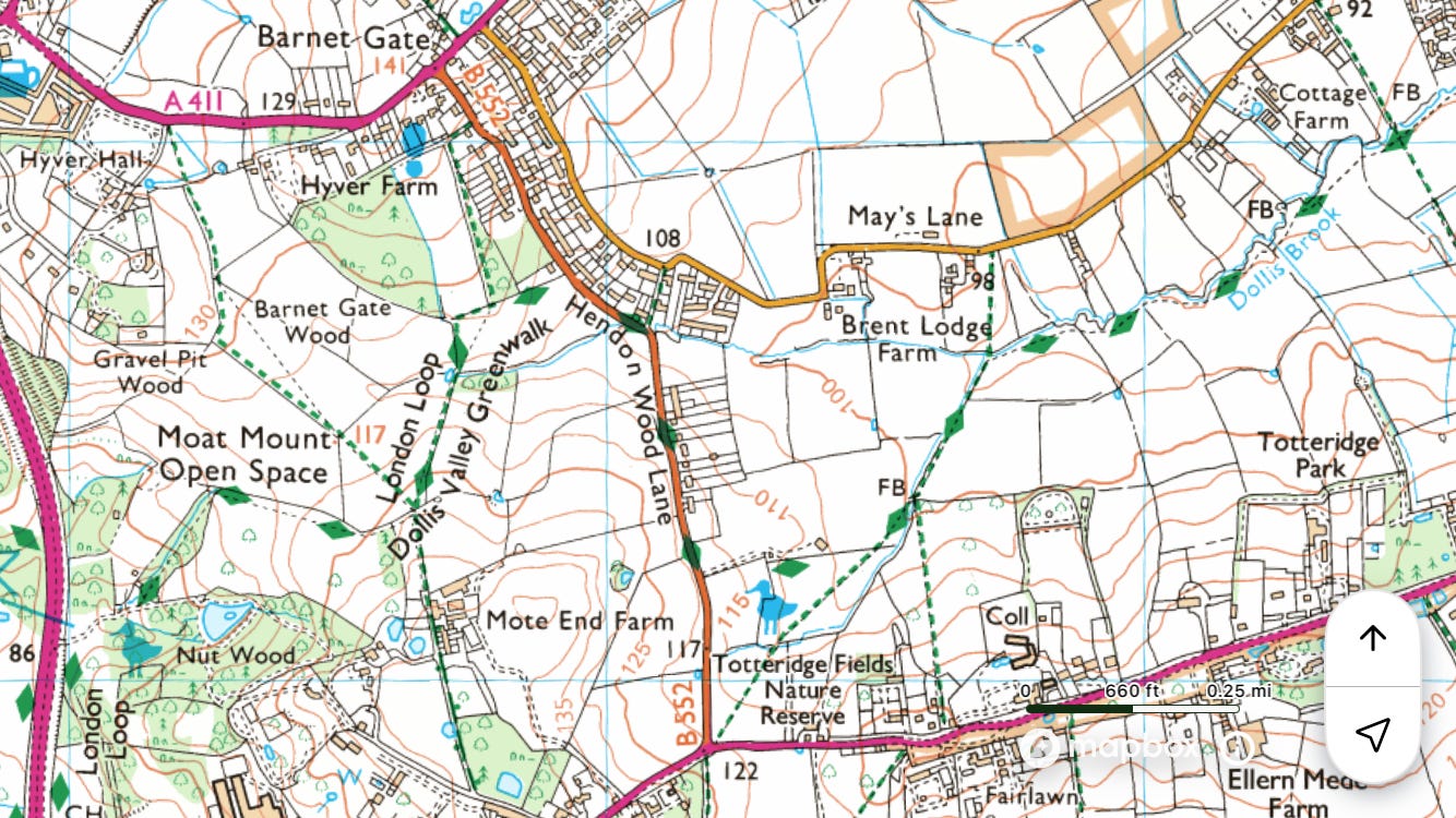
Thameslink to ◉Elstree and Borehamwood
Walk south to join the route at Moat Mount Open Space
Walk south on the Dollis Valley Greenwalk to the Brent / ◉Golders Green or ◉Hampstead Heath
Field notes: It took quite a long time to get from the station to the beginning of the walk (Furze Hill, Scratch Wood, and across the A1). But it’s a really good walk. I was aware of passing through Jewish areas, partly because of ‘FCK HMS’ stickers, which I had never seen before. Dollis Brook is the upper course of the Brent, as Yeading Brook is of the Crane.


Duke of Northumberland’s River
Upper section
See Longford River.
Lower section
~4 miles
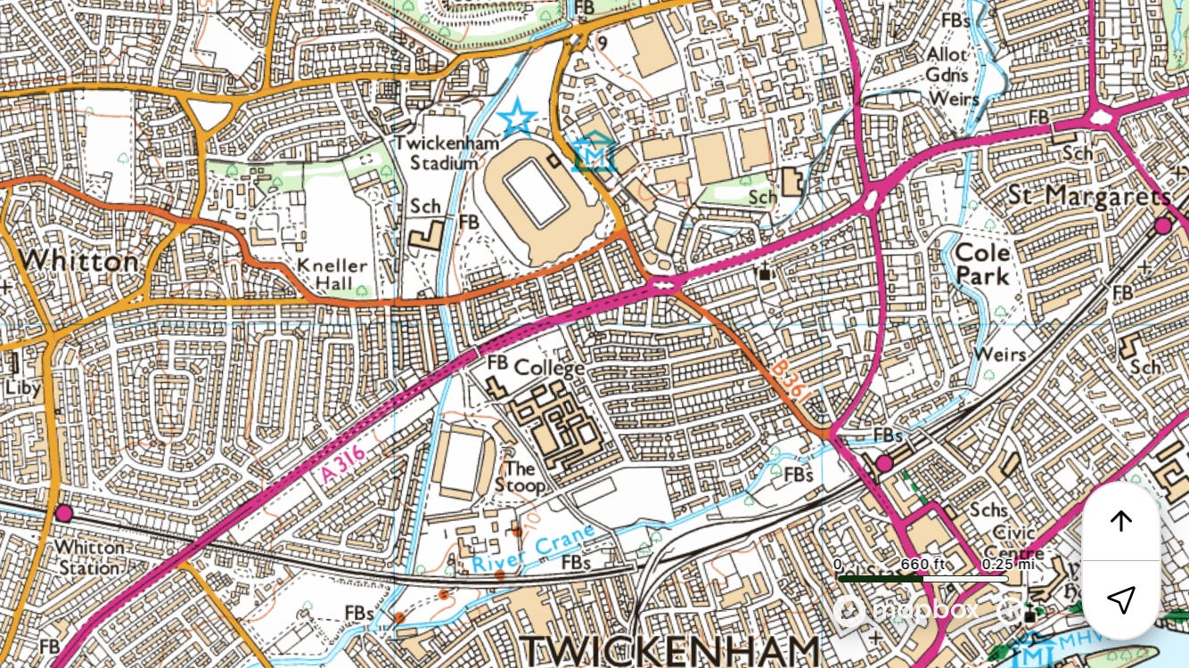
Train to ◉Whitton
Walk north-east on the Duke’s River Walk to the Thames / ◉Isleworth
Field notes: It wasn’t until I’d done most of these walks that I discovered this, pretty much the closest to where I live, the oldest man-made waterway in London, predating the more famous New River by over a hundred years. It is, in effect, a very long mill leat, built to take water from the Crane to the cornmill at Syon Abbey. This lower section was constructed in the late fifteenth or early sixteenth century, and now runs through Billy Williams’s Cabbage Patch (i.e. around Twickenham Stadium) and through Mogden sewage work (there’s a footpath), before making a right and flowing into the Thames. A sluice still feeds the lake in Syon Park.


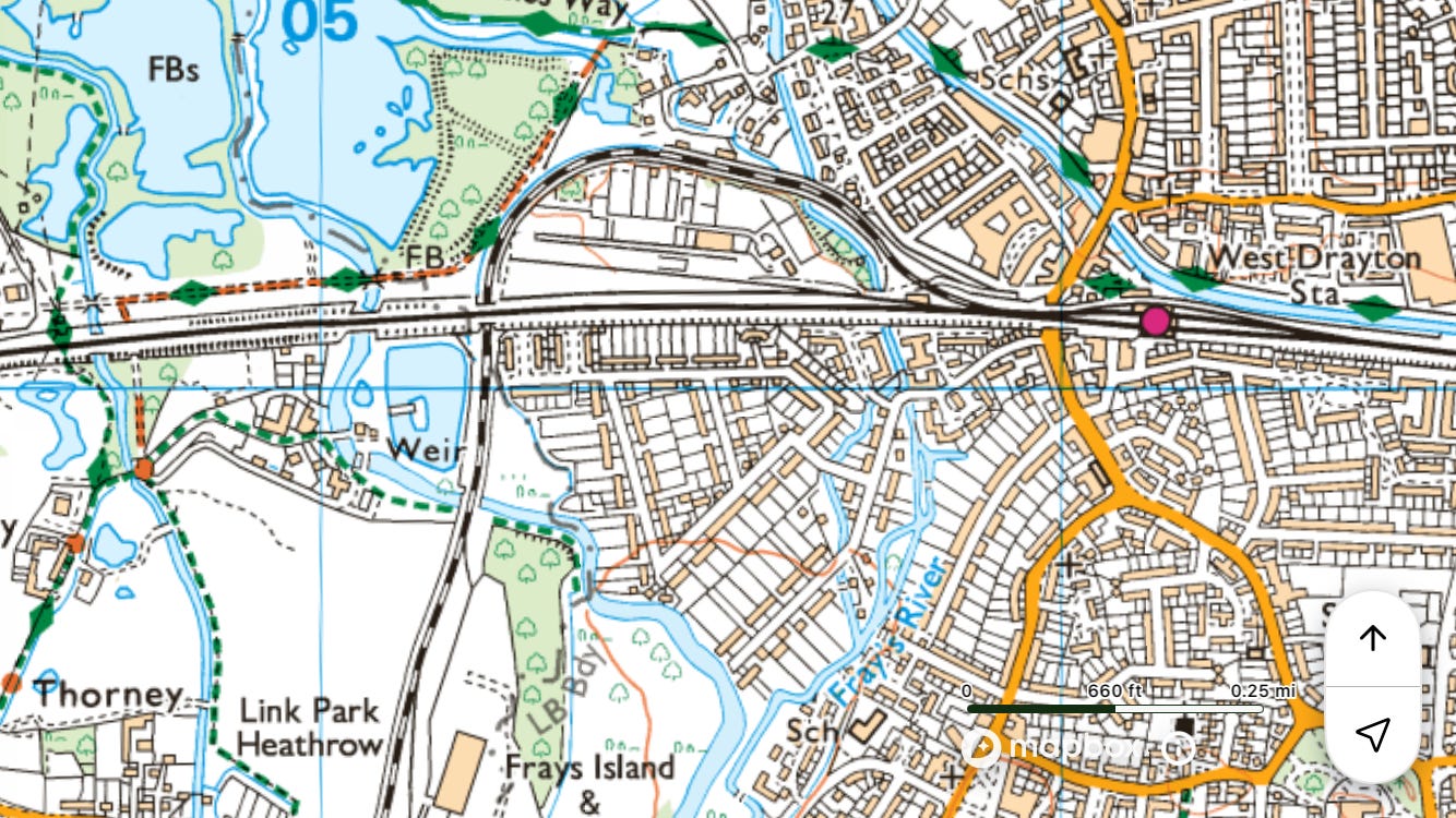
Fray’s River
~8 miles
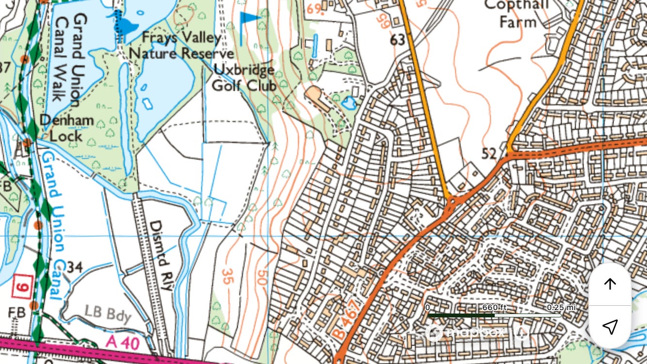
Tube to ◉Ickenham
Walk west to join Fray’s River at Denham Lock
Walk south to the Colne / ◉West Drayton
Field notes: A real find. The wetland area due west of Ickenham is wonderful: Denham Lock Wood / Fray’s Farm meadows / Fray’s Valley nature reserve. Saw muntjac, not that they’re wonderful. I’m intrigued by a mysterious and inviting island in Cowley, formed by the river splitting and coming back together. It doesn’t seem to have a name but was once the home of Cowley Mill, marked on Matthäus Seutter’s map of c. 1730. I’ll call it the River Isle of Cowley Mill. On the modern OS map it looks like a nature reserve – I suppose it is one, but there doesn’t seem to be any access for humans. When I tried to explore I found my way blocked by Monster House, the UK headquarters of Monster Energy. I saw an employee walking back to the office with his lunch. He only had a sandwich, no drink, so maybe they get unlimited complimentary Monster. It’s worth pressing on, south of the Slough arm of the GUC.


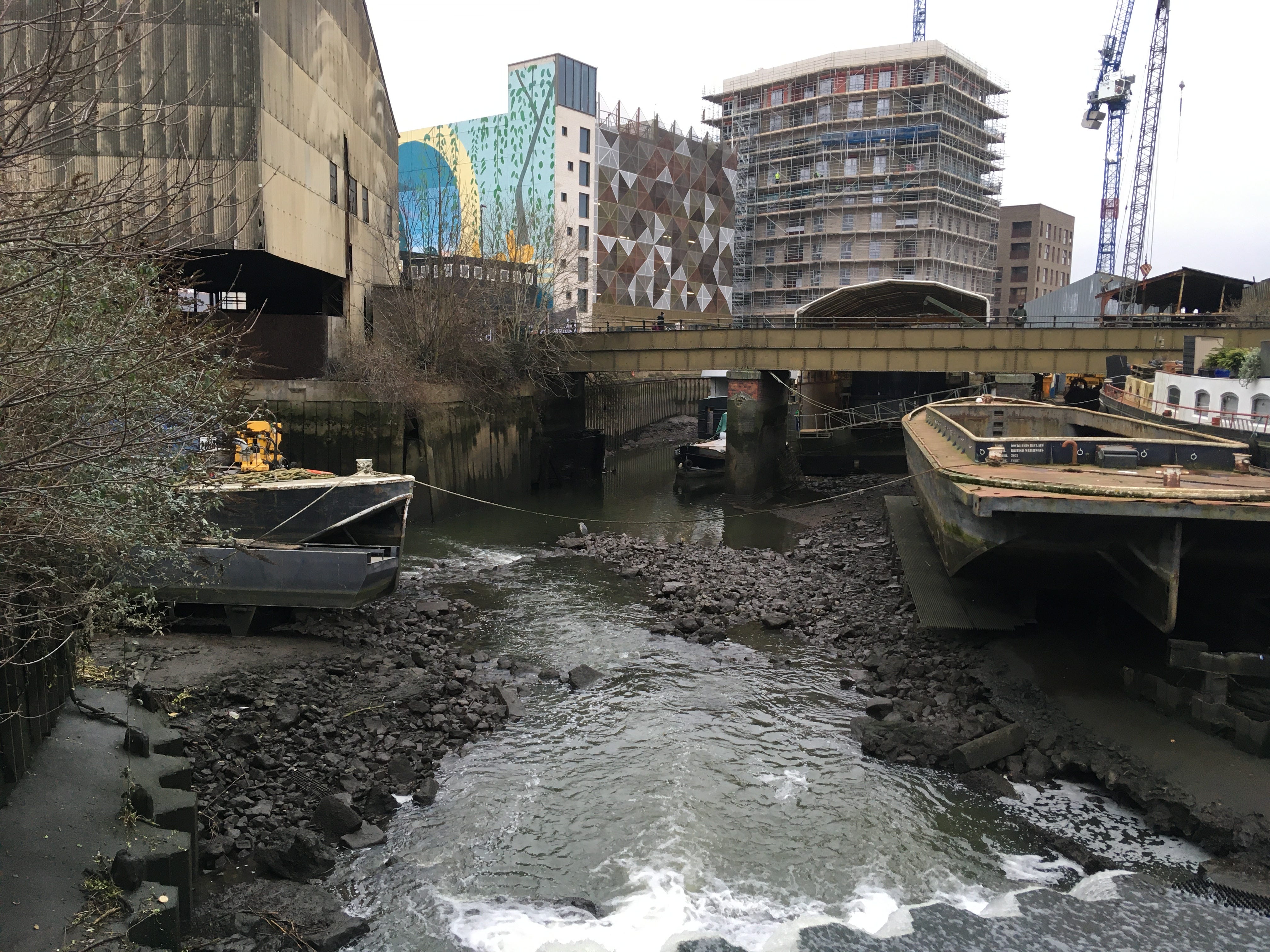
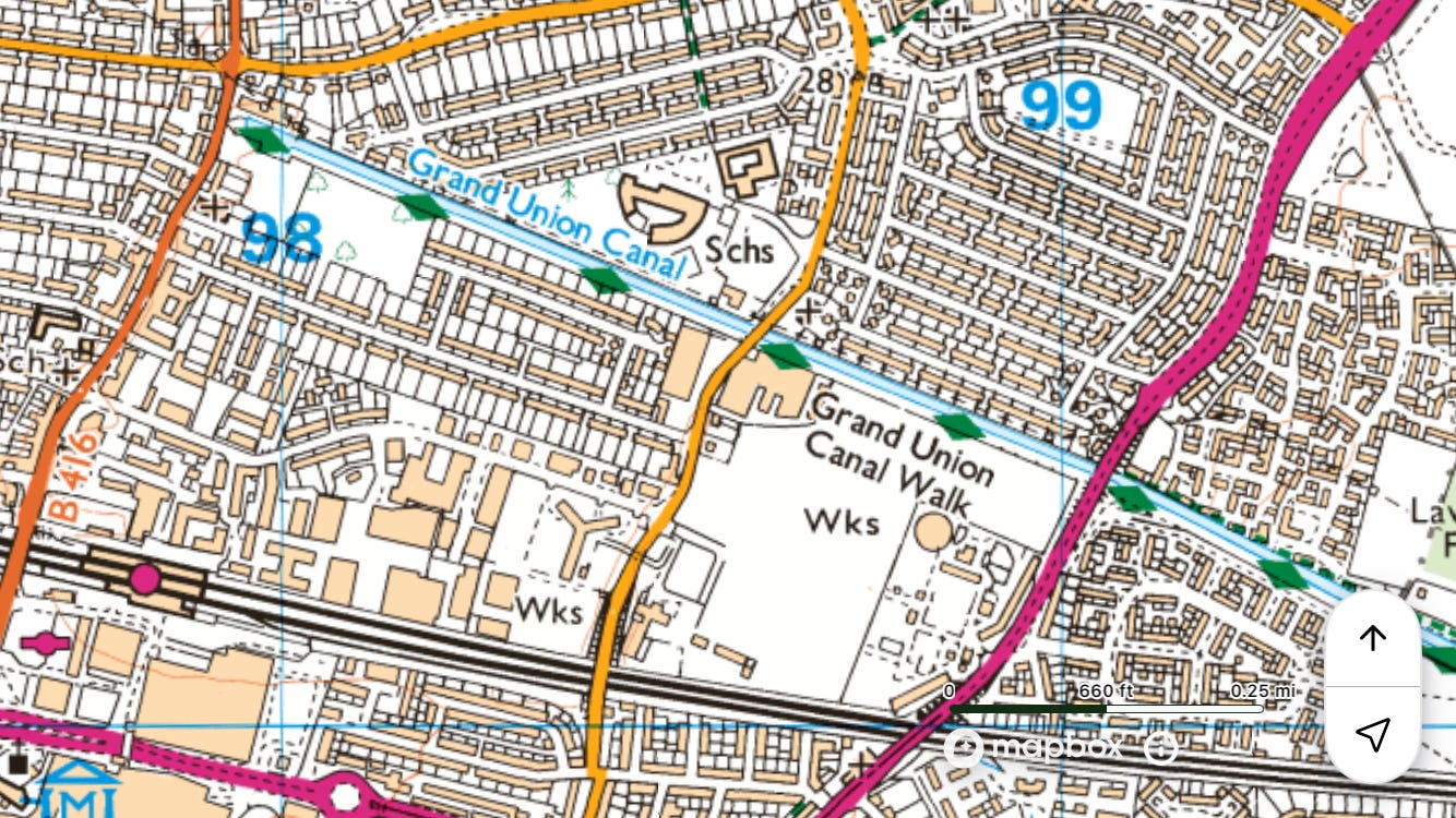
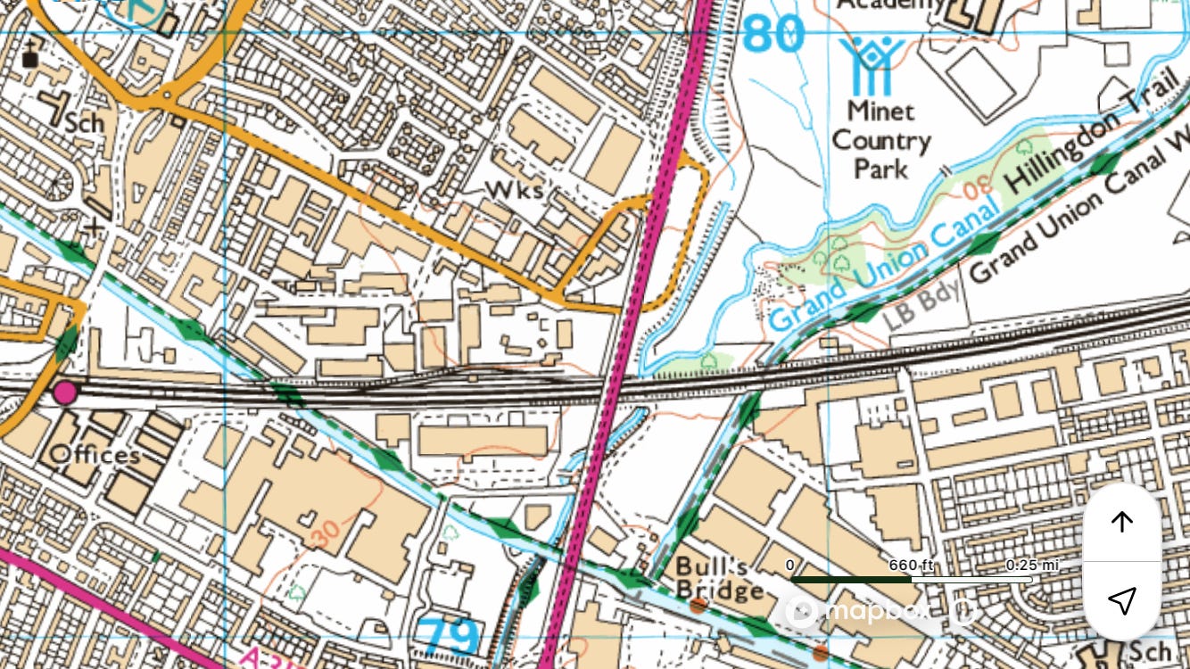
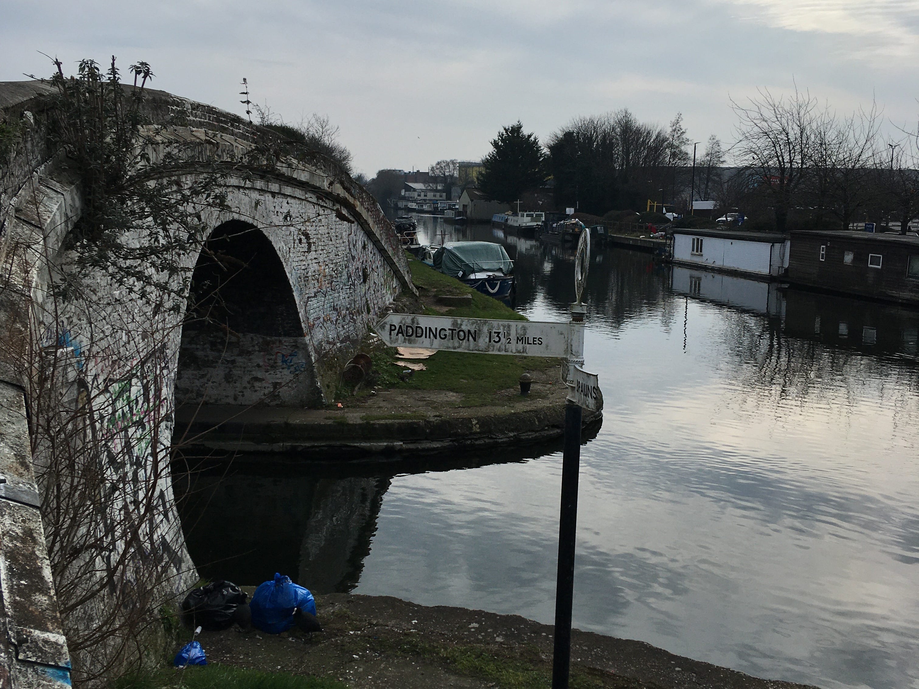
Grand Union Canal
Northern section (incorporating part of the upper Colne)
Partly in Hertfordshire and Buckinghamshire.
~12 miles
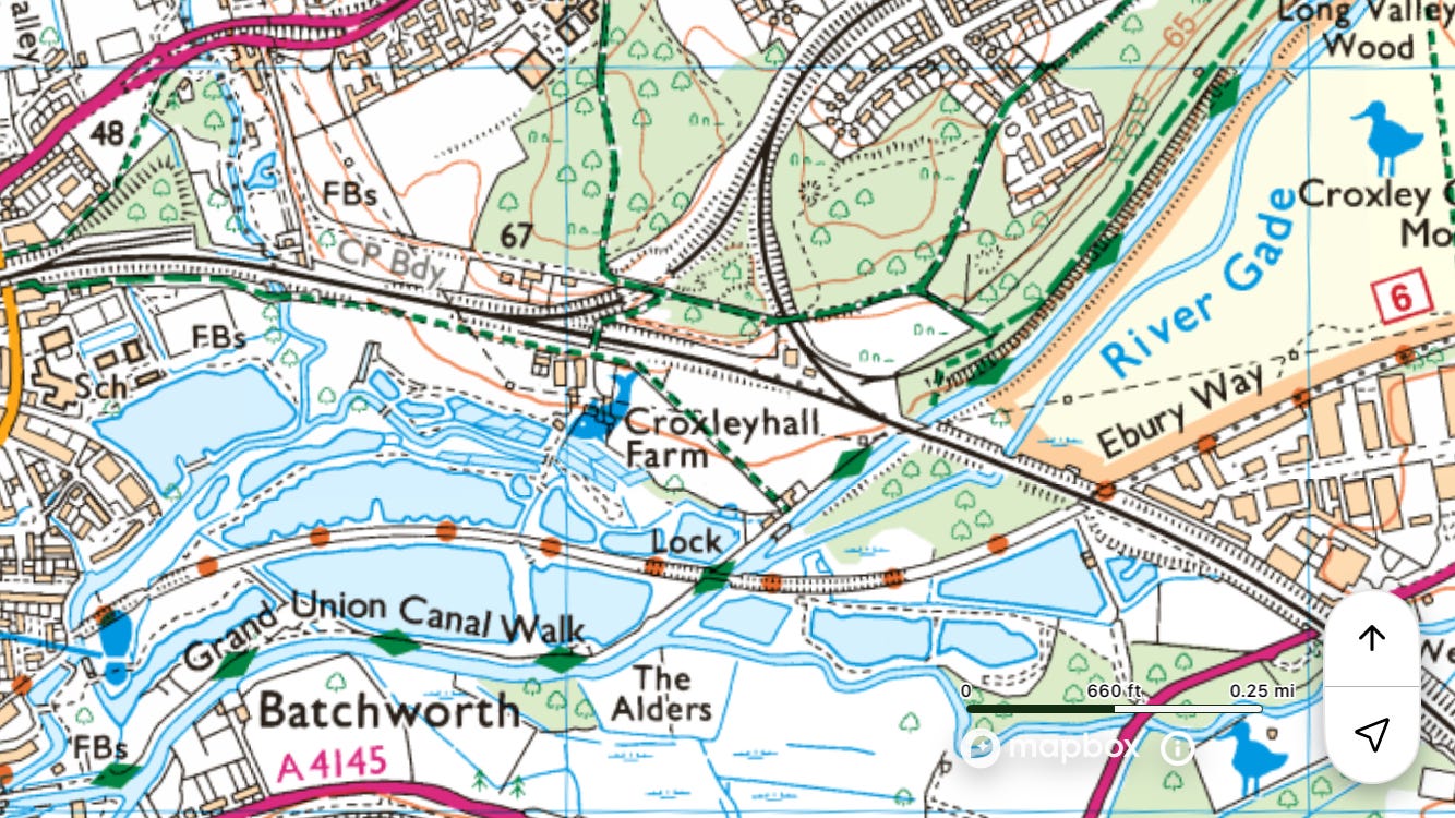
Overground to ◉Bushey
Walk west along the Ebury Way to join the canal
Walk south on the towpath to ◉Uxbridge
Field notes: The Colne Valley Trail is nearby and runs in the same direction most of the way, so often you can choose between the canal and another nearby path. Saw a badger near Maple Lodge nature reserve.


Southern section (incorporating part of the lower Brent)
~13 miles
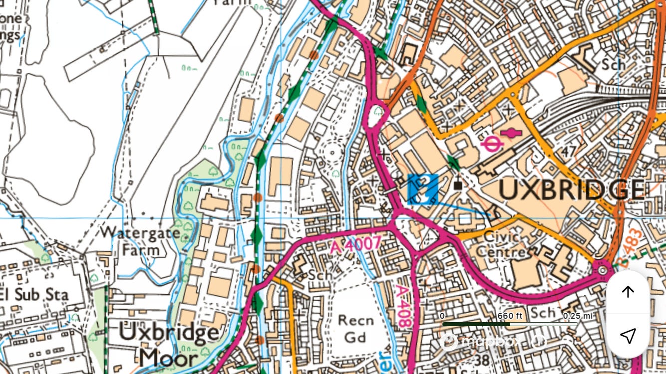
Tube to ◉Uxbridge
Walk south on the towpath to the Thames / ◉Brentford
Field notes: Didn’t find a bench to sit on and have my coffee and sandwich till Hanwell. Lots of litter and dog shit. This is more positive, from Ian Nairn: ‘The complete walk out of London from Paddington to Uxbridge, which I have never done, must be tremendous. Even a short sample is enough to get you hooked on the neglected world of industrial landscape. After it, everything else seems a bit pallid.’3 I prefer walking towards the Thames, but this page is a testament to getting hooked on a neglected world.
Slough arm
Partly in Buckinghamshire.
~13 miles
Elizabeth line to ◉Slough
Walk on the towpath to Packet Boat Marina, then along the main line of the canal east to ◉Hanwell
Field notes: Passing over Colne Brook and then Fray’s River is nothing short of thrilling.


Paddington arm
~14 miles
Elizabeth line to ◉Hayes and Harlington
Join the Paddington arm at Bull’s Bridge
Walk east on the towpath to Little Venice / ◉Paddington
Field notes: Lots of berks on Lime bikes, litter, and polluted air from boats’ wood burners – poor England. Describing Venice, Byron once implied that by contrast the Paddington Canal, though it contained ‘calm water’, was ‘nothing but a clay-coloured ditch’. I did see a kingfisher, though – saw it fly back and forth for a couple of minutes. A highlight is walking by Kensal Green Cemetery, which Ian Nairn calls ‘a friendly piece of melancholy, dust to dust in the gentlest sense, with ragwort and cow parsley covering up all those nineteenth-century bones.’4
River Hogsmill
Partly in Surrey.
~8 miles
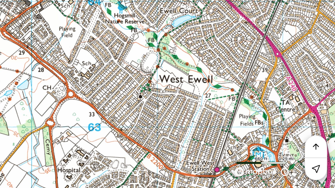
Train to ◉Ewell West
Walk north to the Thames / ◉Kingston
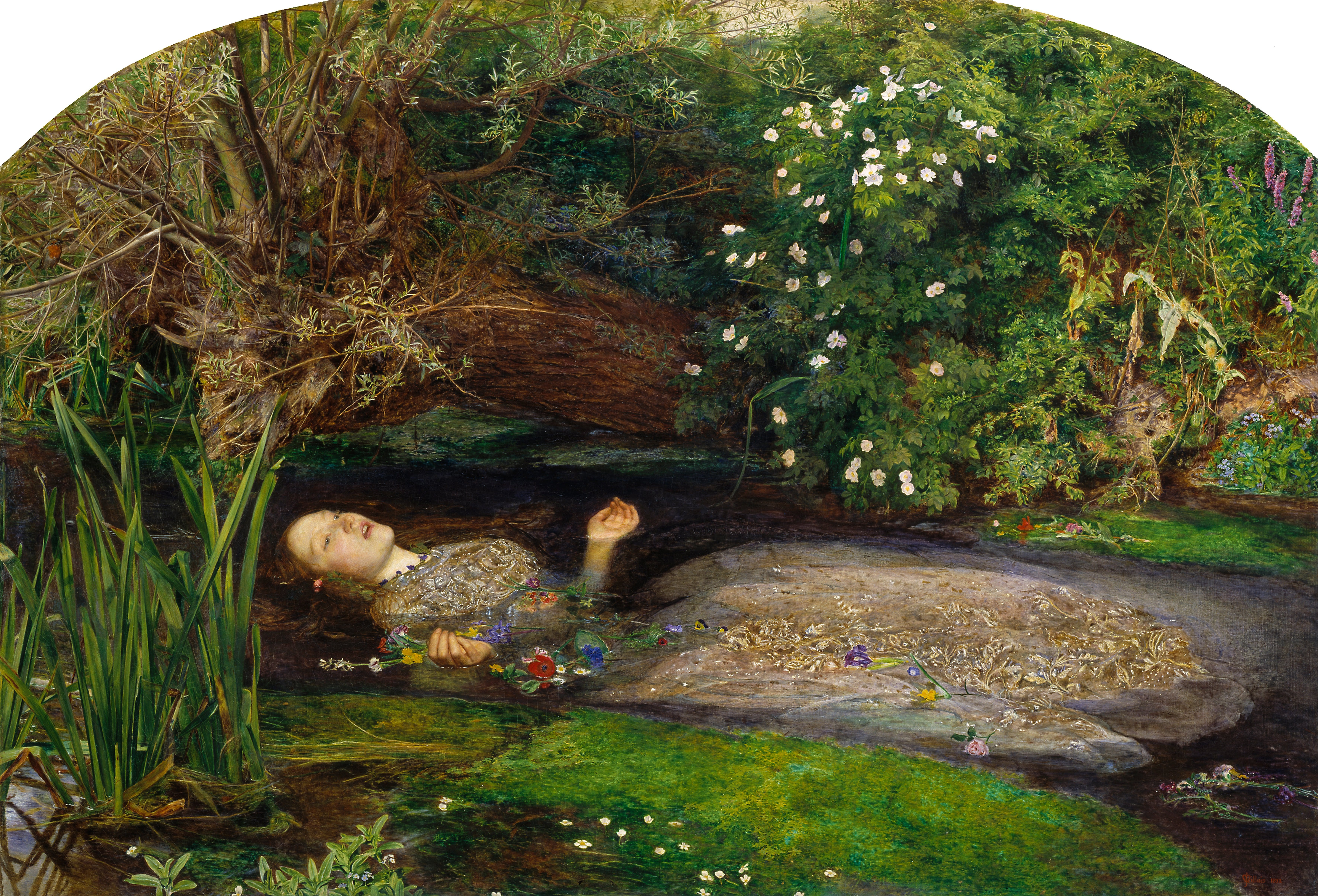
Field notes: Lots of it isn’t very nice, stretches of the path blocked, nettles, etc. Brewer’s Dictionary of London Phrase and Fable calls Worcester Park ‘One of the few districts that blithely straddle the London border as though it were not there […] In 1851 the Pre-Raphaelite artists Sir John Millais and William Holman Hunt spent the summer at Worcester Park Farm. […] Millais probably painted the landscape background for his celebrated work Ophelia (1852) […] from a meadow beside the Hogsmill River, although the precise spot is still the subject of debate.’5
River Ingrebourne
~9 miles
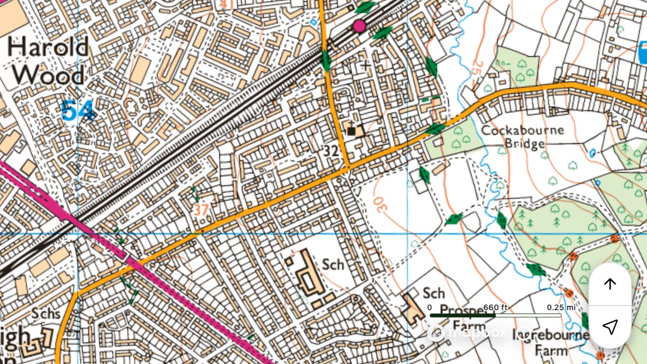
Elizabeth line to ◉Harold Wood
Walk south to ◉Rainham
Field notes: Highlights include open fields north of Upminster and the Ingrebourne Valley nature reserve north of Rainham.


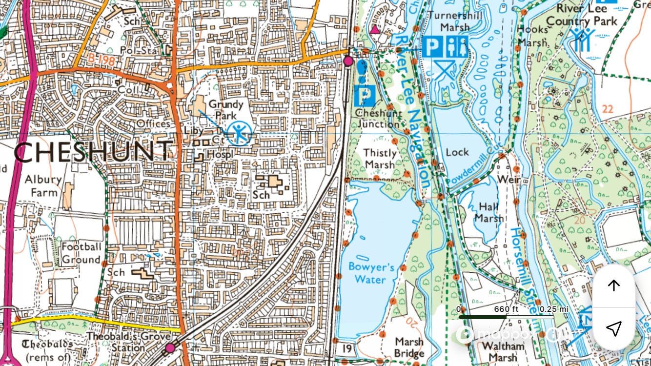
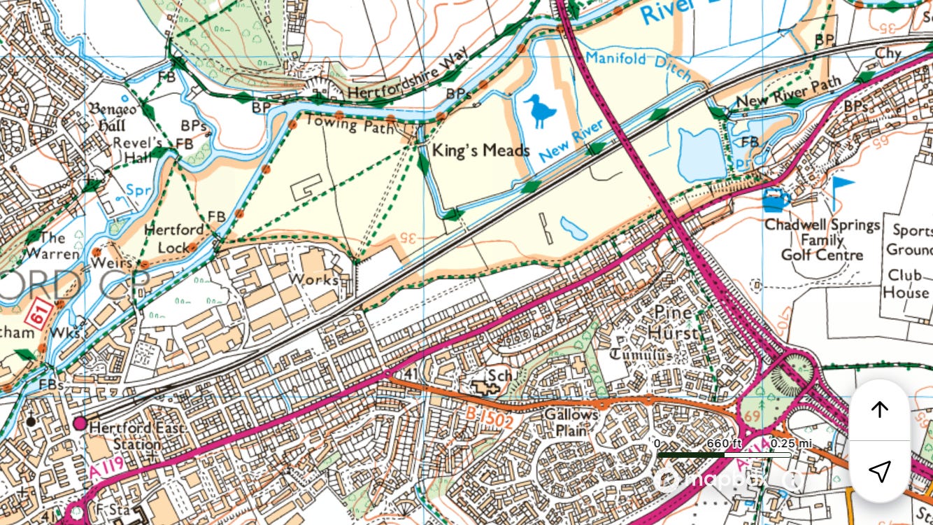
River Lee
Northern section
Hertfordshire.
~11 miles

Train to ◉Hertford East
Walk south on the Lee Navigation towpath to ◉Cheshunt
Field notes: The long, straight section north of Cheshunt is magnificent. Saw a strange poster in the window of a narrowboat. It was a picture of a red squirrel with the caption ‘I love grey squirrels’. I did not see any red squirrels.


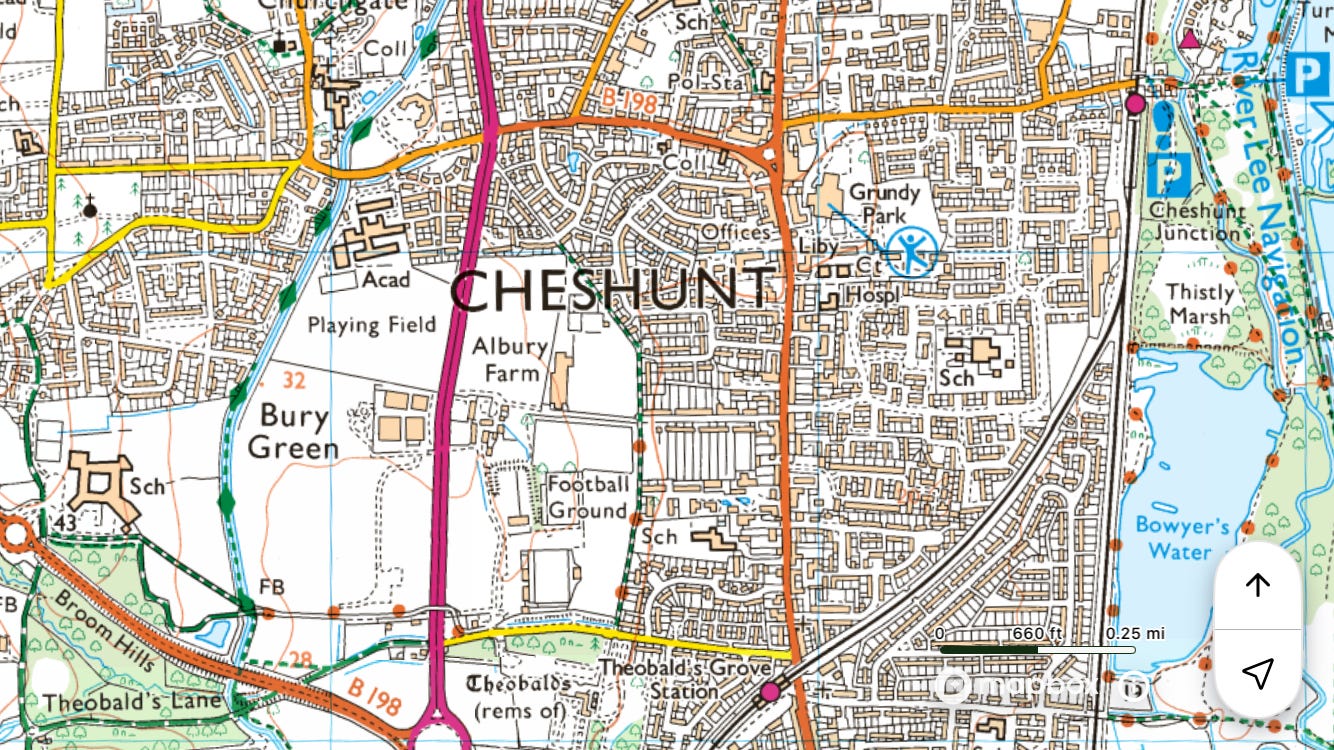
Middle section
Starts in Hertfordshire.
~13 miles
Overground to ◉Cheshunt
Walk south on the Lee Navigation towpath to ◉Hackney Wick
Field notes: Lee water, water everywhere, in the thirteen reservoirs of the Lee Valley chain and in marshes galore. See Pymme’s Brook for Pickett’s Lock.
Southern section
~4 miles
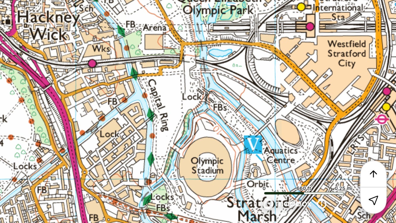
Overground to ◉Hackney Wick
Walk south on the Lee Navigation towpath to the Thames / ◉Limehouse
Field notes: This shorter section is an opportunity to explore the Olympic Park, Mill Meads / Three Mills, the Bow Back Rivers, and the Limehouse Cut.


Longford River
Incorporating the upper Duke of Northumberland’s River
Partly in Buckinghamshire.
~14 miles
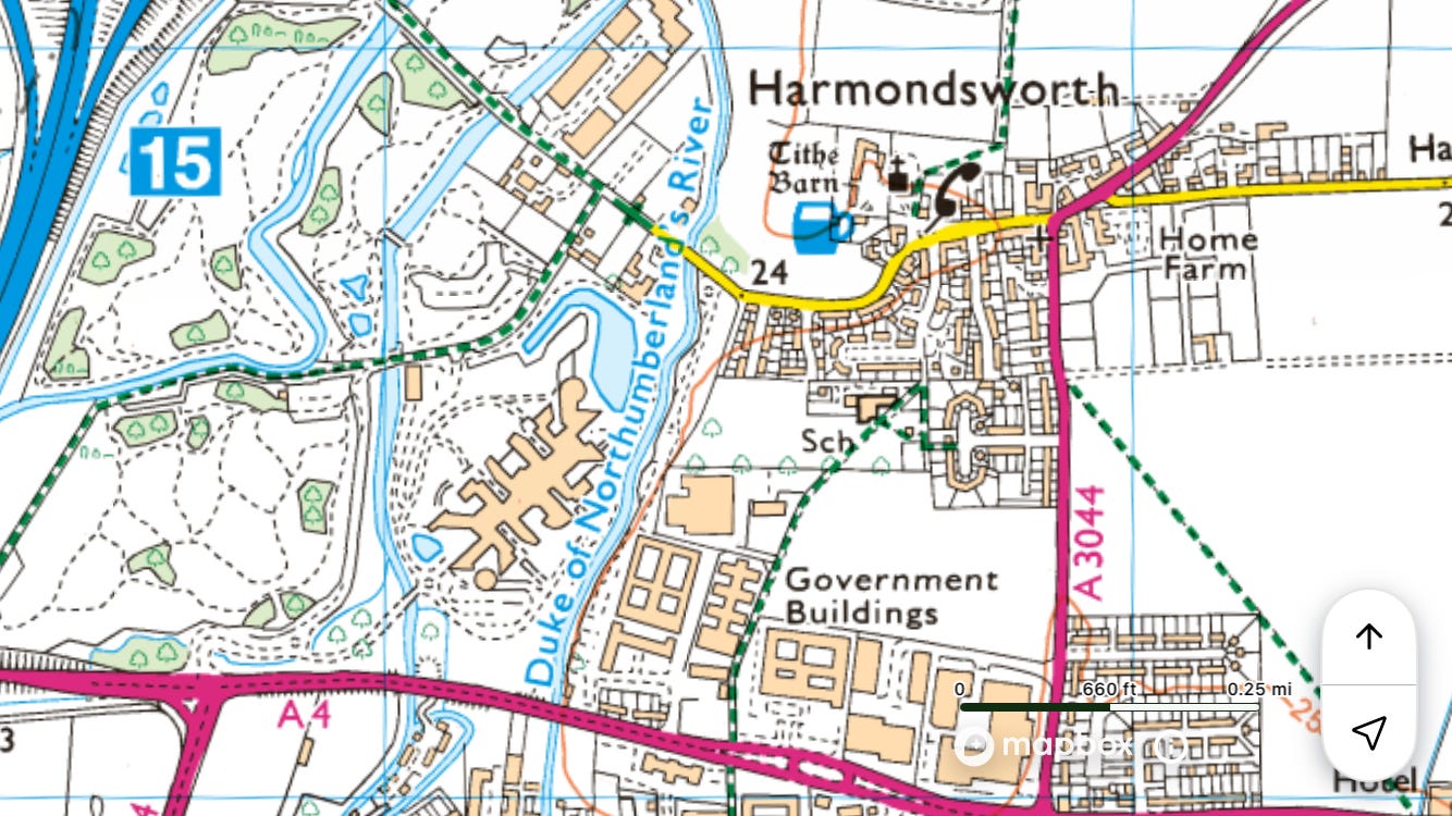
Elizabeth line to ◉West Drayton
Walk south to join the Duke of Northumberland’s River at Harmondsworth
Walk south to Bushy Park / ◉Hampton Court
Field notes: This is quite a long walk, the first section being a good opportunity to see the lower reaches of Fray’s River, Fray’s Island, and sections of the Colne on the other side of the M25 from the Colne Valley Trail/Way. The Duke of Northumberland’s River is, in effect, a mill leat in two sections, the upper emptying into the Crane and the lower drawing from it. It predates the more famous New River, construction possibly having begun in the late fifteenth century! The Longford River, once called Queen’s River, is later, having been built for Charles I, to supply the lakes at Hampton Court with water from the Colne. The semi-surreal highlight of this walk is a section where, thanks to the ‘Twin Rivers Diversion’ of 2004, the two run alongside each other immediately south of Heathrow Airport, creating in the few yards between them a linear park or greenway.


Maye’s Brook
~4 miles
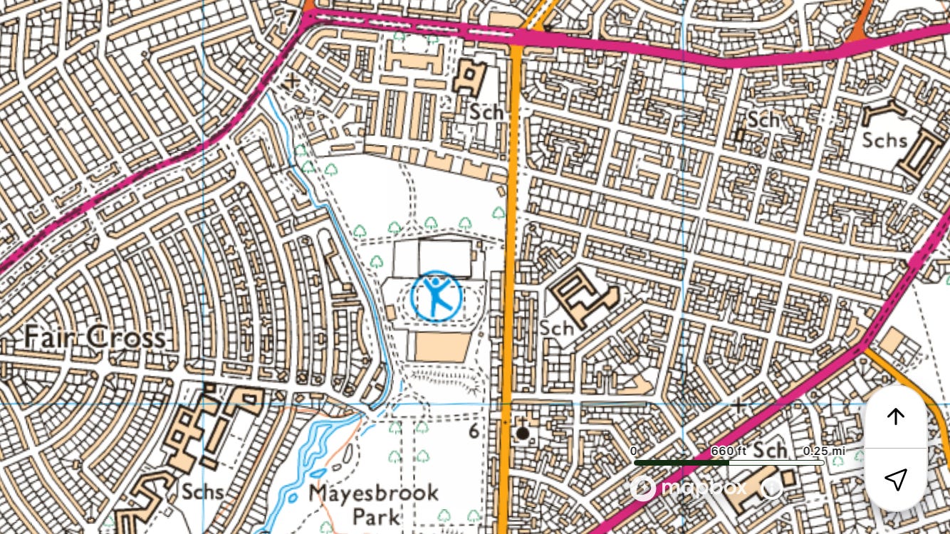
Elizabeth line to ◉Goodmayes
Walk south to the Roding / ◉Upney
Field notes: Including this might be a case of Holy Roman Empire syndrome: neither a good walk, nor a long one, and barely next to a waterway. However, Mayesbrook Park is the UK’s first ‘climate change park’. On Goodmayes, A Dictionary of London Place Names says, ‘It is apparently only coincidence that the stream flowing south near here is called Mayes Brook’, but Goodmayes Park Lake is fed by Maye’s Brook (I think).6


River Mole
Surrey.
~9 miles
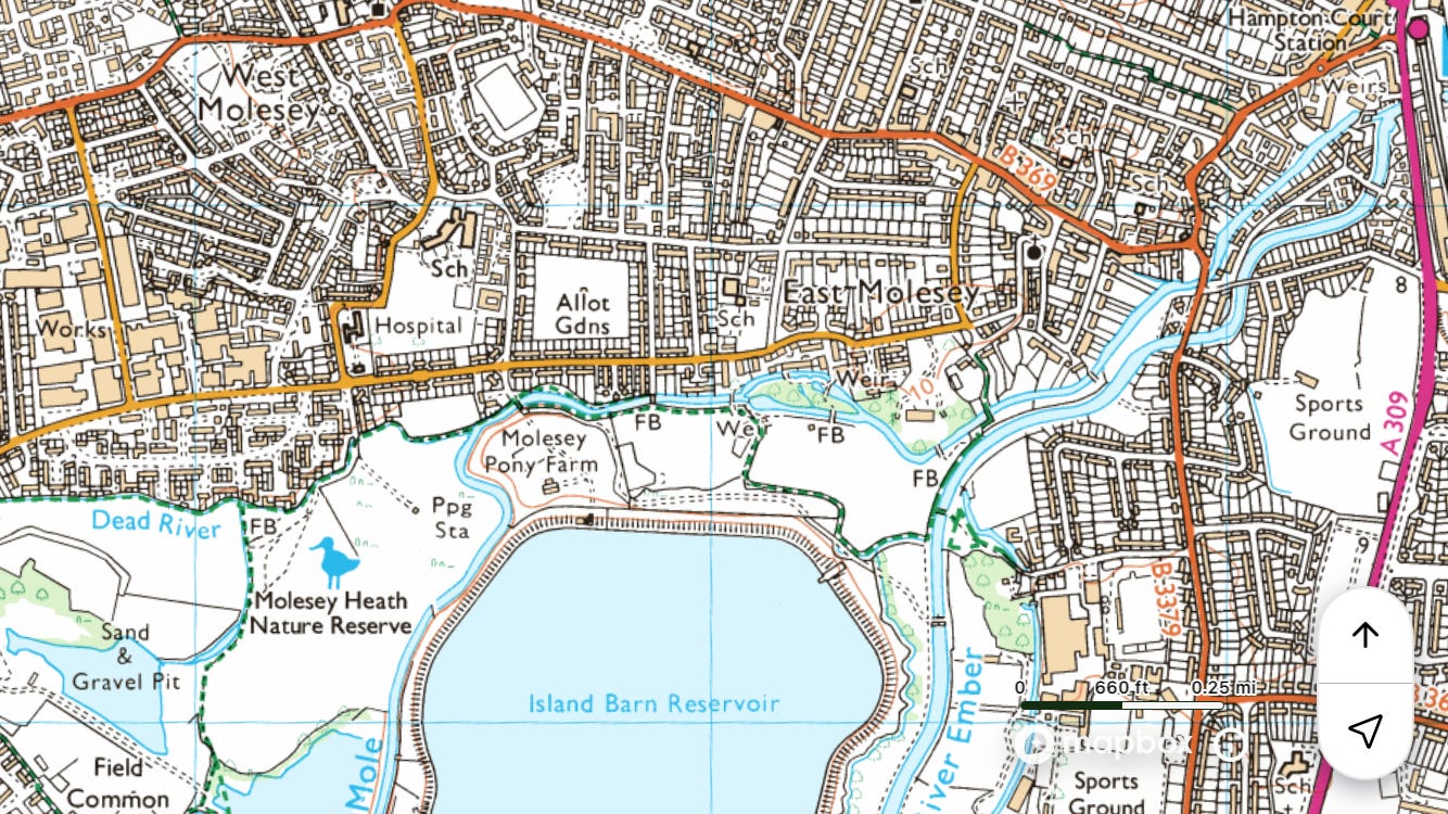
Train to ◉Hampton Court
Walk a clockwise loop with Island Barn Reservoir at its centre, back to ◉Hampton Court
Field notes: Walked along the Ember (an anabranch of the Mole), on footpaths as far as Hersham Trading Estate, along the road next to Queen Elizabeth II Reservoir, along Dead River (a tributary of the Mole), over Molesey Heath alongside the Mole, and back through East Molesey to Hampton Court. Molesey is so nice, especially around St Mary’s Church and the Bell. (I’ve never typed ‘Mole’ so many times.)


New River
Northern section
Hertfordshire.
~12 miles
Train to ◉Hertford East
Walk east along the Lee to join the New River
Walk south on the New River Path to ◉Cheshunt
Field notes: Helpfully, Hertford East is now in the London contactless zone. Unhelpfully, the gate at the pedestrian level crossing in King’s Meads has been locked by Network Rail, so I had to go all the way back to the Lee and around. So in hindsight the walk could begin by getting the train to Ware, but then you’d miss out on seeing the very pleasant, because deserted, first section.


Southern section
Starts in Hertfordshire.
~16 miles
Overground to ◉Cheshunt
Walk west to join the New River at College Road
Walk south on the New River Path to New River Head / ◉King’s Cross
Field notes: The New River (a.k.a. the Old Aqueduct) isn’t the ideal walk because of how frequently one has to detour. It would be impossible to do it without a map, just following signs. Plus even some sections that are usually open are currently closed for resurfacing. Going over the M25 was thrilling. Being in bits of London I don’t like makes me feel mournful. The people and the architecture are so harsh, ugly, and slovenly. Dickheads cycling Lime bikes on the pavement. Villainous teens vaping on the tube.


River Pinn
~12 miles
Tube to ◉Pinner
Walk south on the Celandine Route to the Grand Union Canal / ◉West Drayton
Field notes: The Celandine Route isn’t on the OS, which makes it harder to navigate than it would be. Diversion around an HS2 building site at Gatemead Farm.


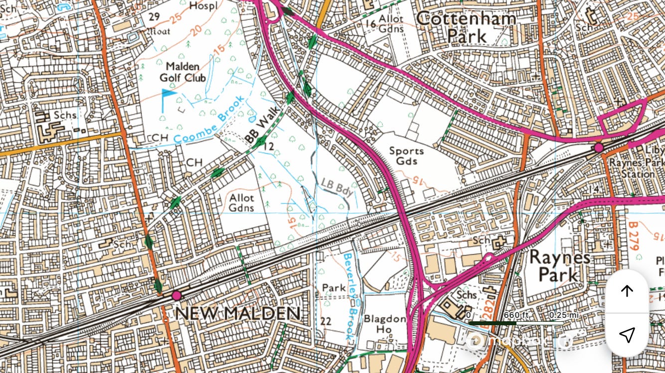
Pyl Brook
~5 miles
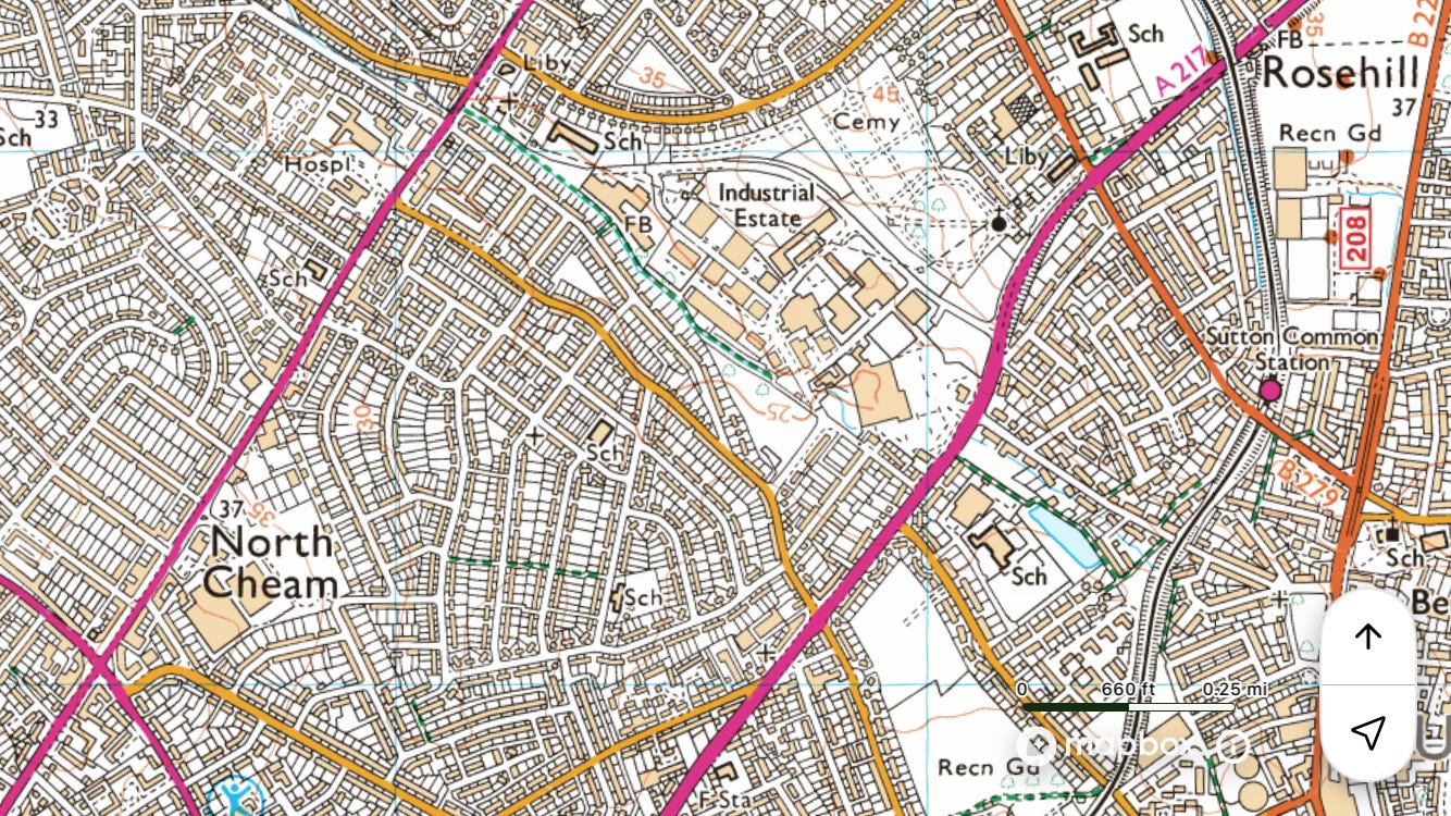
Train to ◉Sutton Common
Walk north-west to Beverley Brook / ◉New Malden
Field notes: Morden Cemetery is a highlight.


Pymme’s Brook
~15 miles
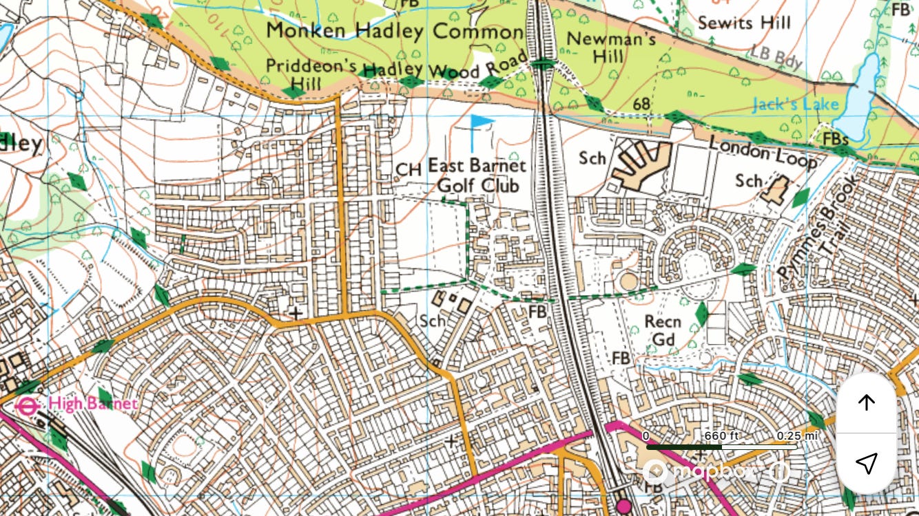
Tube to ◉High Barnet
Walk north-east to join Pymme’s Brook at Monken Hadley Common
Walk south on the Pymme’s Brook Trail to the Lee / ◉Tottenham Hale
Field notes: On all the signs, ‘Pymmes Brook’ is written without an apostrophe, but it’s named after a man called Pymme, so should have one. Quite a nice walk, sometimes next to, sometimes in the vicinity of the brook. Crosses the New River at Palmers Green. The only section that’s locked and overgrown is the four hundred yards east of Millfield House in Edmonton. Of all the places I’ve been on these walks, Lee Park Way, south of Pickett’s Lock, might be the most strangely desolate. At the north end was a group of truants burning wooden pallets, for fun or warmth I’m not sure. To my left was the Lee Navigation, then the soaring embankment of a reservoir, to my right a sewage works, and pylons above.


River Quaggy
Also known as Chin Brook in the place of that name
~5 miles
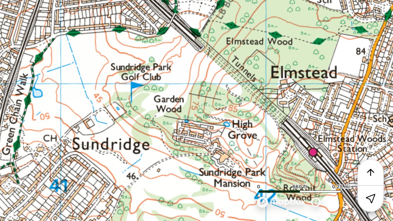
Train to ◉Elmstead Woods
Walk through Elmstead Wood on the Green Chain Walk to join the Quaggy at Chinbrook Meadows
Walk north to the Ravensbourne / ◉Lewisham
Field notes: Met a nice woman in Chinbrook Meadows (this section of the river is also known as Chin Brook). She’s the chair of the friends group and told me about how the area between the railway lines was brought back to life. I also saw on another sign a reference to the Quaggy Waterways Action Group (QWAG), which I enjoyed. I can confirm that in Sutcliffe Park the ground around the river is indeed quaggy. Apparently, ‘It was notorious for causing floods [here] near Lee Green in the early 19th century’ (A Dictionary of London Place Names).7


River Ravensbourne
Incorporating part of the River Pool
~8 miles
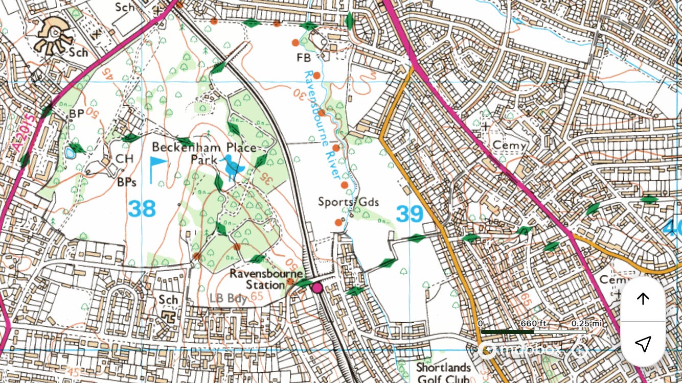
Train to ◉Ravensbourne
Walk north on the Ravensbourne Greenway and Waterlink Way to ◉Deptford
Field notes: Followed the Ravensbourne Greenway for all of a mile, through Beckenham Place Park, but didn’t hear of it after that. More extensive is Waterlink Way, which I joined at Bellingham, to walk along the River Pool, a tributary of the Ravensbourne.


Regent’s Canal
~9 miles
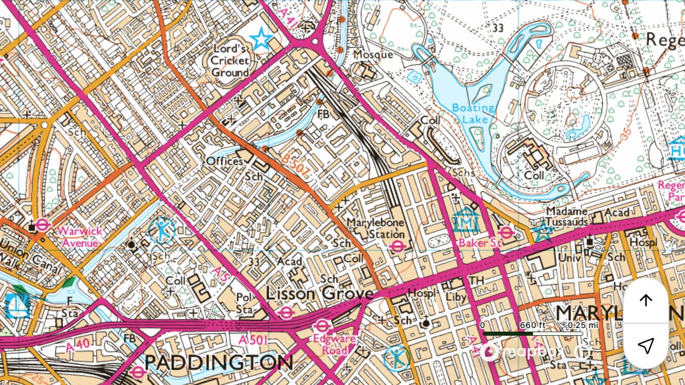
Tube to ◉Warwick Avenue
Walk east on the towpath to ◉Limehouse
Field notes: A highlight is where its course passes along the northern edge of Regent’s Park.


River Roding
Partly in Essex.
~10 miles
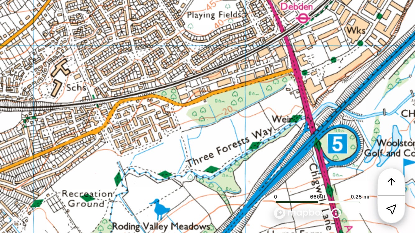
Tube to ◉Debden
Walk south to ◉Manor Park
Field notes: OS map essential for when you have to go away from the riverbank.


River Rom
Also known as the Beam below its confluence with the Ravensbourne
~12 miles
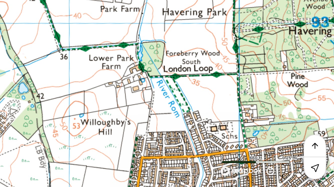
Tube to ◉Hainault
Walk east to join the Rom at Hainault Forest
Walk south to ◉Dagenham East
Field notes: Walked from the tube station to the river via Cabin Hill, the hundred top of Becontree. A sane person might consider sections of the walk less than rewarding.


Salmon’s Brook
~11 miles
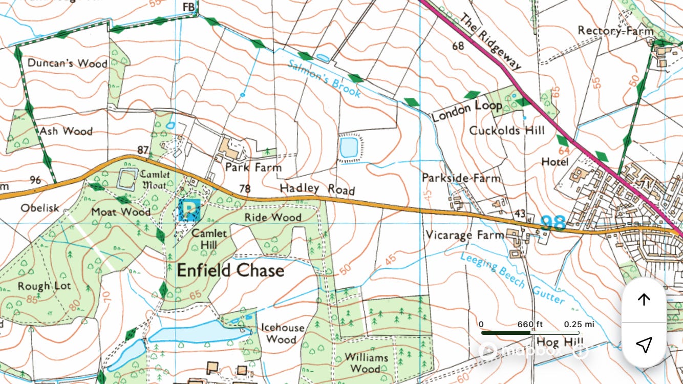
Tube to ◉Cockfosters
Walk north through Trent Park and Enfield Chase to join Salmon’s Brook
Walk east to the railway line (one of the Lee Valley lines), then to ◉Meridian Water
Field notes: Salmon’s Brook is named after John Salemon of Edmonton, not the fish. It’s not possible to stay by the river the whole time, but highlights include: ‘Enfield Chase landscape restoration’, the point where it passes under the New River south of Enfield, Bury Lodge Wetlands, Edmonton Federation Cemetery, and Montagu Recreation Ground.


River Shuttle
~6 miles
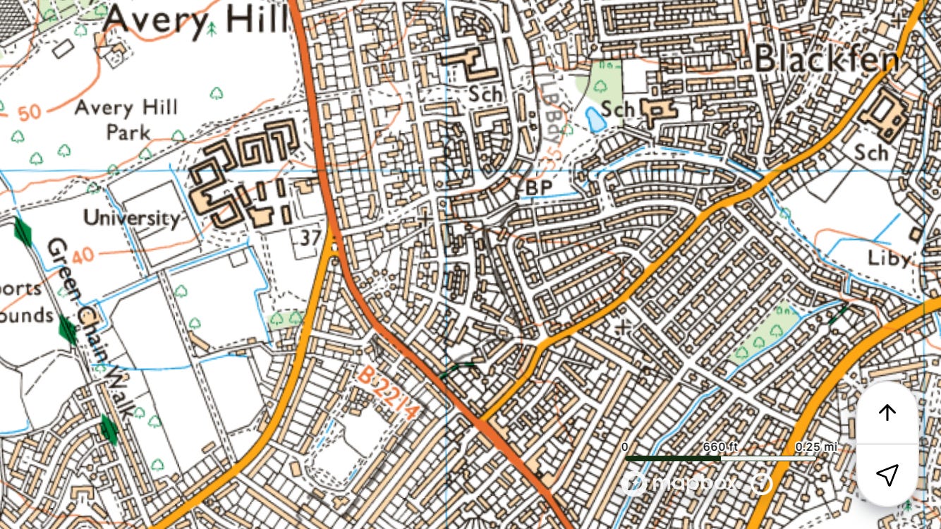
Train to ◉Mottingham
Walk east on the Green Chain Walk, around Eltham Palace, to join the Shuttle at Avery Hill Park
Walk east along the Shuttle Riverway to the Cray / ◉Bexley
Field notes: There are some nice riparian linear parks along the way. The etymology of ‘Shuttle’ is apparently obscure. I wondered if it might be from the sense ‘A flood-gate which opens to allow the flow and regulate the supply of water in a mill-stream’ (OED) – perhaps to do with a mill on the Cray – but computer (AI) says no.


Silk Stream
~9 miles
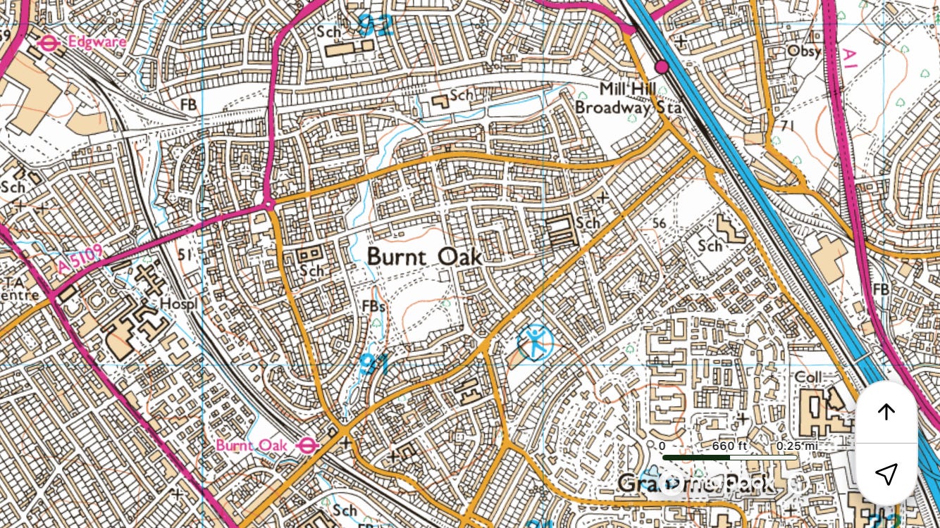
Tube to ◉Edgware
Walk south on the Silk Stream Way to the Welsh Harp (Brent Reservoir) / ◉Wembley Park
Field notes: Highlights include Silkstream Park and the Welsh Harp nature reserve at the end. ‘Silk’ is from the Old English ‘sulh’, meaning ‘a narrow gully’.


Turkey Brook
With the potential to stray into Essex.
~6 miles or ~11 miles
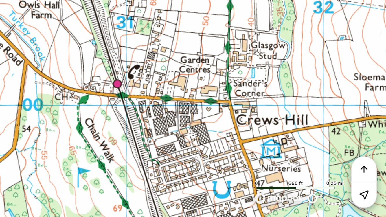
Train to ◉Crews Hill
Walk east, partly along the London Loop, to ◉Enfield Lock, or extend to ◉Chingford
Field notes: Like ‘Ravensbourne’, the etymology of ‘Turkey Brook’ and ‘Turkey Street’ has been folk-feathered, the original Tokestrete (recorded 1441) meaning something like ‘street of houses (i.e. hamlet) of the Tokey family’. Recorded 2026, UK identifiers: CCTV, forsaken cable ties, litter-plus, and enormous piles of dog shit.


River Wandle
~13 miles
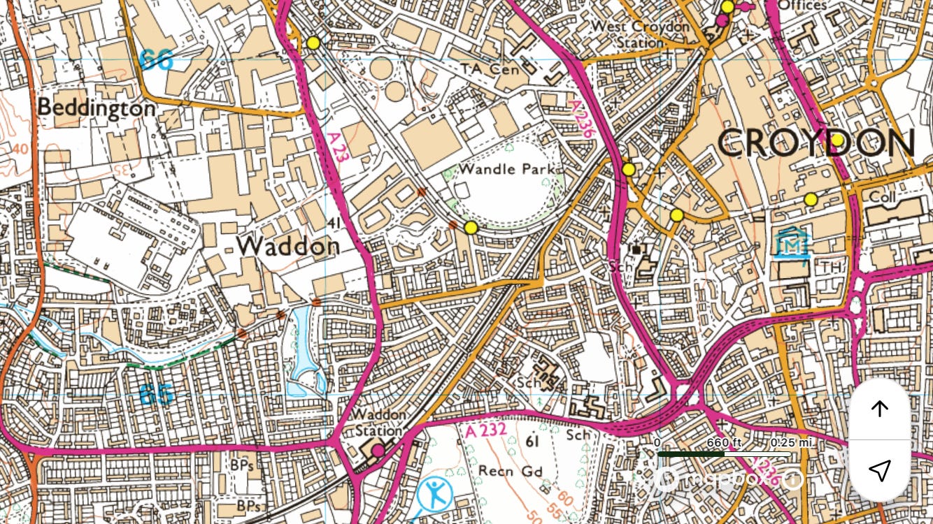
Train to ◉West Croydon
Walk north on the Wandle Trail to the Thames / ◉Wandsworth Town
Field notes: The London Encyclopædia says, ‘Admiral Nelson used to fish in the Wandle where part of it flowed in Lady Hamilton’s garden at Merton Place, she having diverted it and called it “the Nile” in his honour.’8 By contrast, in London’s Lost Rivers Tom Bolton notes that ‘it was categorised as a sewer during the 1960s.’9


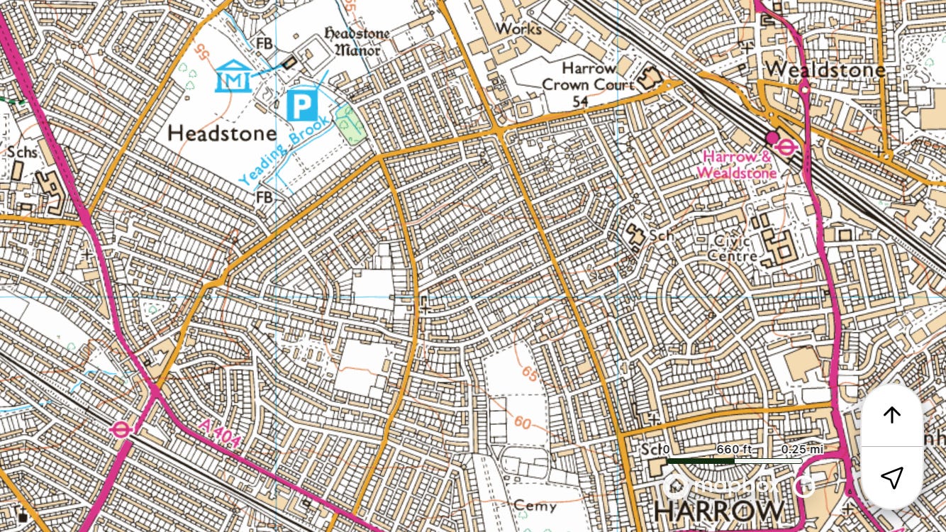
Wealdstone Brook
~5 miles
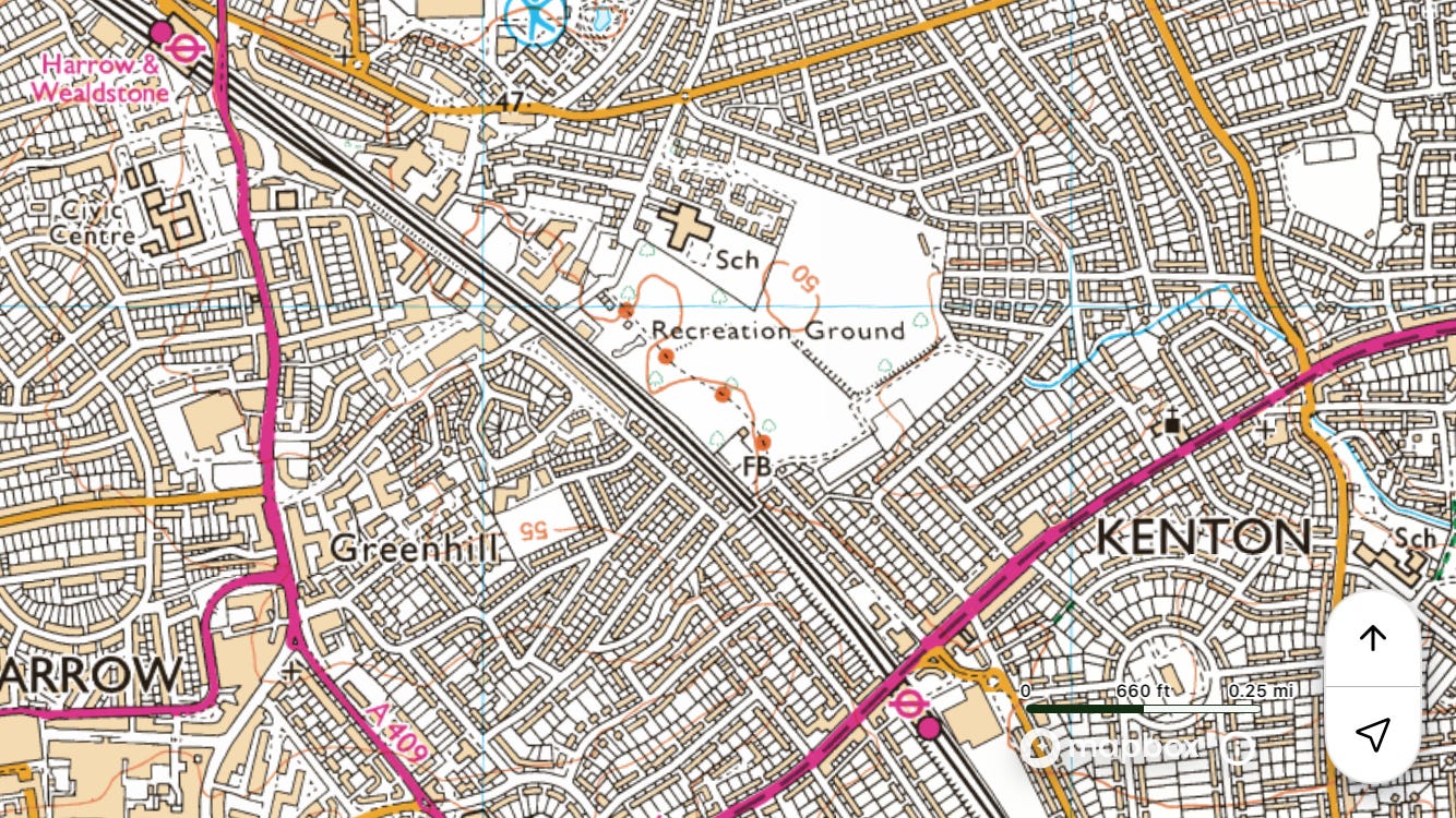
Overground to ◉Harrow and Wealdstone
Walk south to ◉Wembley Park
Field notes: There isn’t a huge amount of the river that can be walked along, so divert to see Fryent Country Park and climb Barn Hill from where there’s a good view of Wembley Stadium.


River Wey
Surrey.
~18 miles
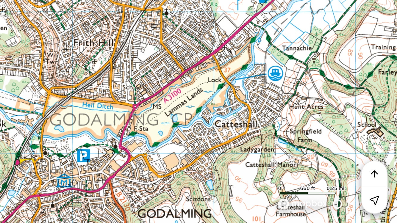
Train to ◉Godalming
Walk north on the Wey Navigation towpath to ◉Byfleet and New Haw
Field notes: The Wey is a wonderful rural channel lined by cow meadows and blackberry hedges.


River Wraysbury
Partly in Buckinghamshire.
~6 miles
Elizabeth line to ◉West Drayton
Walk south to ◉Staines
Field notes: Cattle by the Colne on Staines Moor. To the west is the Wraysbury and, as far as I can work out, the longest stretch of path that runs right next to the M25 – about 1.5 miles. I can’t think of anyone else who would consider it a good or nice or worthwhile place to go, but I liked it. On the wider, tarmacked stretch of the path were three boys on motor scooters, doing wheelies. One caught my eye and grinned, another wheelied close to me, perhaps to intimidate. When I was having my sandwich in a secluded corner of the moor I heard two more scooters go by, so there might have been five of them. They seemed to have access, by having broken in, to a little hut belonging to Thames Water or some such agency. I glanced in and saw a kitchen sink and a socket with a phone plugged in, charging. Quite homely. They might have been skiving year elevens or a bit older.


Yeading Brook
~12 miles
Overground to ◉Harrow and Wealdstone
Walk south, partly on the Hillingdon Trail, to the Grand Union Canal / ◉Hayes and Harlington
Field notes: This is the upper course of the Crane. In modern times the name changes at or near the GUC. Nice woods and wide-open spaces south of the A40. Got a bit trapped in Minet Country Park due to building work and a locked gate over a bridge.


Ben Weinreb and Christopher Hibbert, eds., The London Encyclopædia (London: Macmillan, 1983), p. 84.
Iain Sinclair, London Orbital: A Walk Around the M25, (London: Penguin, 2003), p. 240.
Ian Nairn, Nairn’s London (London: Penguin, 2014), p. 228.
Nairn, p. 227.
Russ Willey, Brewer’s Dictionary of London Phrase and Fable (Edinburgh: Chambers Harrap, 2009), p. 571.
A. D. Mills, A Dictionary of London Place Names, 2nd edn (Oxford: Oxford University Press, 2010), p. 99.
Mills, p. 201.
Weinreb and Hibbert, eds., p. 921.
Tom Bolton, London’s Lost Rivers: A Walker’s Guide (London: Strange Attractor, 2011), p. 232.
Really interesting and informative too .... thank you!